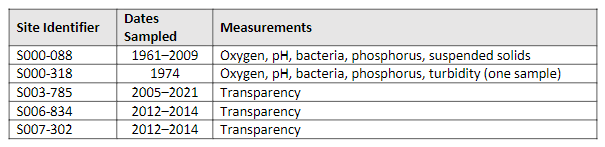
Stream ID
Minnesota Department of Natural Resources (MNDNR) stream ID M-055-005
The Minnesota Pollution Control Agency (MPCA) stream ID for Nine Mile Creek is the Hydrologic Unit Code (HUC) 07020012-809. This link provides information on stream quality that is summarized in the following table. There were additional sites established in the data base, but these are not included in the table because they had no associated data.
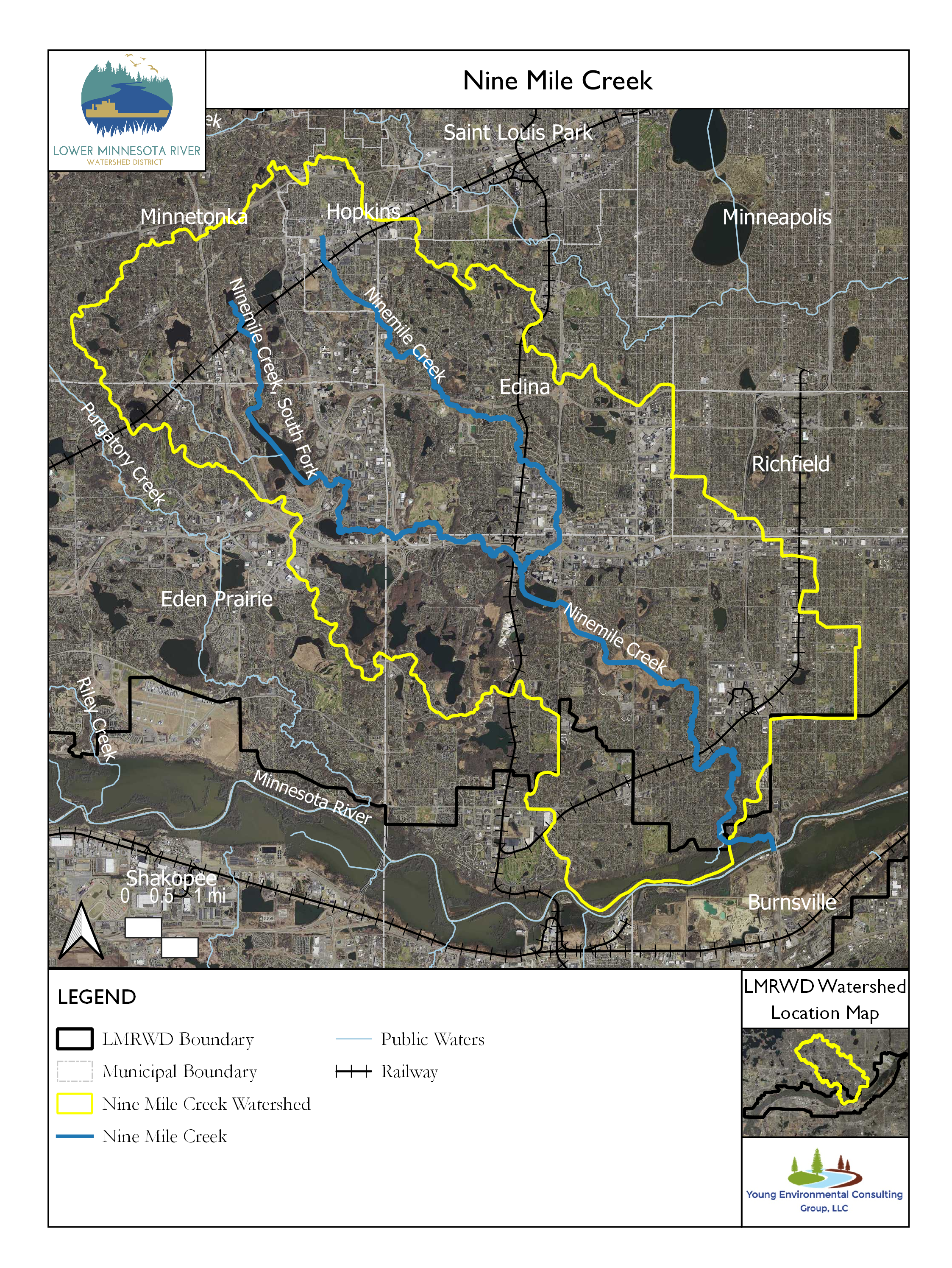
Nine Mile Creek, also known as Ninemile Creek, is a 15-mile (24-kilometer) stream located in Hennepin County that drains about 50 square miles (13,000 hectares; MCES, 2014a). After flowing south through several lakes and communities, Nine Mile Creek empties into the Minnesota River. The watershed is 64 percent developed urban land, and the remainder is woodland, grassland, wetland, and open water (MCES, 2014a). Nine Mile Creek is impaired for aquatic life by elevated chloride concentrations (MPCA, 2022). Its designation of impairment is also based on benthic macroinvertebrate bioassessments and fish bioassessments. Our expectation is that these impairments will be addressed by 2028 (MPCA, 2022). Only a small portion of the Nine Mile Creek watershed (near the mouth of the creek) is in the Lower Minnesota Watershed District (LMRWD).
The Nine Mile Creek Watershed District (NMCWD) sampling program focuses on indicators of biological integrity. Scientists routinely monitor the fish and invertebrate communities and the habitat at selected sites along the creek. The NMCWD hydrographers also sample Nine Mile Creek near the confluence with the Minnesota River for selected indicators of water quality from specific sites (NMCWD, 2022).
Hydrographers from the Metropolitan Council of Environmental Services (MCES) sample Nine Mile Creek as part of the Comprehensive Water Quality Assessment of Select Metropolitan Area Streams (MCES, 2014a), sometimes identified as the Watershed Outlet Monitoring Program (WOMP; MCES, 2017). The site sampled by the MCES, designated by station ID NM0018, is subject to the most comprehensive, ongoing collection of water chemistry data from Nine Mile Creek. The site is 1.8 miles (2.9 kilometers) upstream from its confluence with Minnesota River. The following graphsi (MCES, 2022) summarize selected results of sample analyses from the creek.
Monitoring Data
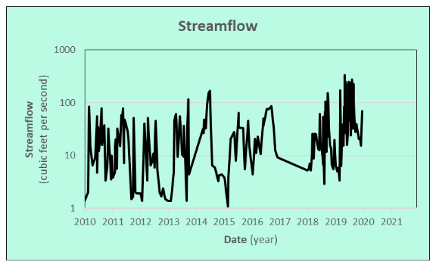
Streamflow
Samples collected from Nine Mile Creek’s streamflow—the amount of water carried by the creek at the sampling site—are shown in the adjacent chart. The streamflow data are processed separately from the other data, and the streamflow measurements for 2020–21 had not been updated in the database when the data were downloaded on March 28, 2022.
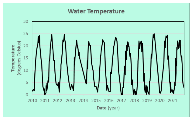
Water Temperature
The water temperature of Nine Mile Creek is important for habitat because warmer water holds less dissolved oxygen (DO) needed by many aquatic organisms. Temperatures at the sampling site fluctuate seasonally, rarely exceeding 77° Fahrenheit (25° Celsius) in the summer and averaging near 32°F (0°C) in the winter.
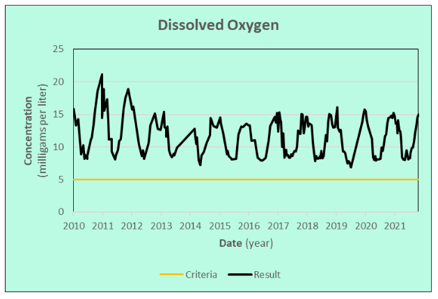
Dissolved Oxygen
DO concentration measurements show that Nine Mile Creek remains well oxygenated. Aquatic animals typically need at least 5 milligrams per liter (mg/L) of DO (MNDNR, 2021). Seasonal fluctuations are normal because oxygen solubility changes with water temperature. The value of 21 mg/L on February 13, 2011, is higher than usual for natural waters, because at the sample temperature of 0.8°C (33°F), the creek is expected to hold no more than 14.3 mg/L.
Transparency
The adjacent graph shows the transparency, a measure of water clarity, of Nine Mile Creek. High transparency in a stream indicates clear water that is carrying little suspended material. Low transparency implies that the stream is turbid and carrying a lot of sediment. Streams carrying runoff tend to be turbid and have low transparency while they might otherwise run clear. Most of the readings from Nine Mile Creek are at 100, suggesting that the transparency often exceeds the 100-centimeter limit of the tube used to measure the transparency.
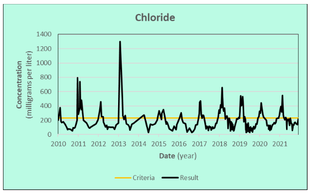
Chloride
Chloride, a primary component of road deicing and water-softening salt, represents a growing concern for many streams and lakes. The chronic standard for chloride in Minnesota waters to protect cool and warm water fisheries is 230 mg/L (MPCA 2018).
Nine Mile Creek has the second highest concentration of chloride in the Minnesota River basin streams monitored by MCES, which reflects the densely developed, urban nature of the watershed (MCES, 2014b). A Total Maximum Daily Load study for Nine Mile Creek chloride levels was approved in 2010, and it estimated that a 62% reduction in chloride was required to eliminate the impairment (MCES, 2021).
The adjacent graph shows the Nine Mile Creek chloride concentrations since 2010. Although the large spikes observed in earlier years are more subdued now, concentrations continue to exceed the 230 mg/L criteria. Peak concentrations usually occur in the winter.
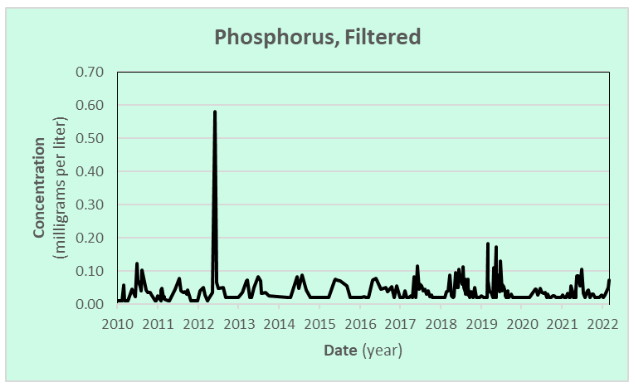
Phosphorus
Phosphorus is an essential plant nutrient that is carried by streams. Naturally occurring phosphorus concentrations may be enriched from animal wastes and fertilizers and phosphorous is often introduced with runoff. Phosphorus is often associated with sediment but is more available to plants when it is dissolved in the water. The adjacent charts show the concentrations of phosphorus in samples from Nine Mile Creek. The first chart shows the total amount of phosphorus in the water, including the part associated with particulate matter containing suspended sediment. The second chart shows the phosphorus remaining in the water after the sample has been filtered to remove the sediment-associated phosphorus.

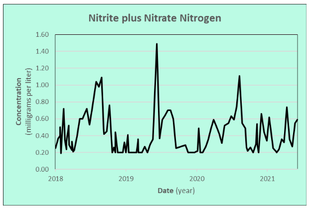
Nitrogen
Nitrogen is also an essential plant nutrient carried by streams, and naturally occurring concentrations may be similarly enriched from animal wastes and fertilizers. Nitrite plus nitrate nitrogen is a commonly measured form of nitrogen that is readily available for plants. It is highly water soluble and often found as a contaminant in groundwater beneath agricultural land. At concentrations above 10 mg/L, much higher than measured in Nine Mile Creek, it may be toxic to humans. The method used to analyze the samples cannot accurately quantify levels below 0.20 mg/L, so 0.20 mg/L is the lowest concentration reported.
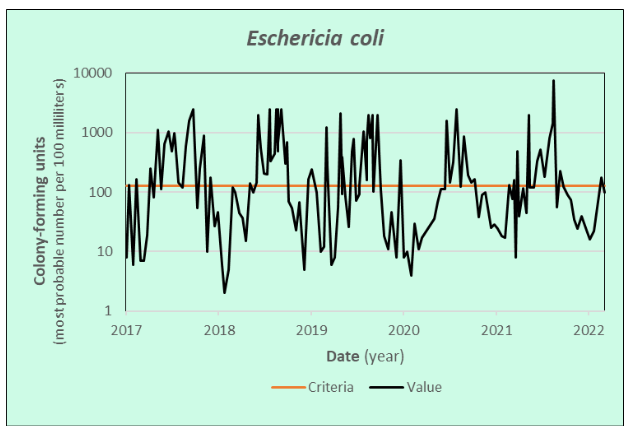
Escherichia coli
Escherichia coli (E. coli) is a bacterium measured to quantify the amount of fecal contamination in lakes and streams. Swimming in or ingesting water with high levels of E. coli could result in illness. The allowable limit is a monthly average of fewer than 126 colony-forming units per 100 milliliters of water between April and October (MPCA, 2021). Nine Mile Creek often has levels of E. coli that exceed the allowance for recreation and human health.
References
MCES. (2014a). Comprehensive water quality assessment of select metropolitan area streams. St. Paul, MN: Metropolitan Council Environmental Services.
MCES. (2014b). Nine Mile Creek Fact Sheet. St. Paul, MN: Metropolitan Council Environmental Services. Retrieved Mar 29, 2022, from https://metrocouncil.org/Wastewater-Water/Services/Water-Quality-Management/Stream-Monitoring-Assessment/Minnesota-River-Tributary-Streams-Assessment/Mn-River-Trib-Assessment-Reports/Nine-Mile-Creek-Factsheet.aspx
MCES. (2017). Joint Powers Agreement with the Minnesota Pollution Control Agency for the Watershed Outlet Monitoring Program. St. Paul, MN: Metropolitan Council Environmental Services. Retrieved Mar 31, 2022, from https://metrocouncil.org/Council-Meetings/Committees/Metropolitan-Council/2017/12-13-17/1213_2017_288-SW.aspx
MCES. (2021). Nine Mile Creek Chloride. St. Paul, MN: Metropolitan Council Environmental Services. Retrieved Mar 29, 2022, from https://www.ninemilecreek.org/wp-content/uploads/Item-8i-2021-March-17-Nine-Mile-Creek-Board-Meeting_Nine-Mile-Creek-Partner-Chloride-Memo_Corresponsdence.pdf
MCES. (2022). Minnesota River Streams. Retrieved Mar 30, 2022, from Comprehensive Water Quality Assessment of Select Metropolitan Area Streams: https://metrocouncil.org/Wastewater-Water/Services/Water-Quality-Management/Stream-Monitoring-Assessment/Minnesota-River-Tributary-Streams-Assessment.aspx#top
MNDNR. (2021). Stream Basics | Minnesota Department of Natural Resources. Retrieved Nov 3, 2021, from https://www.dnr.state.mn.us/fishing/trout_streams/stream_basics.html
MPCA. (2018, May 18). TCMA Chloride TMDL - Applicable Water Quality Standards and Numeric Water Quality Targets. Retrieved Nov 8, 2021, from https://stormwater.pca.state.mn.us/index.php/TCMA_Chloride_TMDL_-_Applicable_Water_Quality_Standards_and_Numeric_Water_Quality_Targets
MPCA. (2021). Water Quality and Bacteria Frequently Asked Questions. Retrieved Mar 31, 2022, from https://www.pca.state.mn.us/sites/default/files/wq-s1-93.pdf
MPCA. (2022). Minnesota's Impaired Waters List. (M. P. Agency, Producer) Retrieved Jun 21, 2022, from Imparied Waters: draft 2022: https://www.pca.state.mn.us/water/minnesotas-impaired-waters-list
NMCWD. (2022). Lake and Creek Monitoring. Retrieved April 4, 2022, from Nine Mile Creek Watershed District: https://www.ninemilecreek.org/whats-happening/lake-creek-monitoring/
This data was last updated March 2022.